
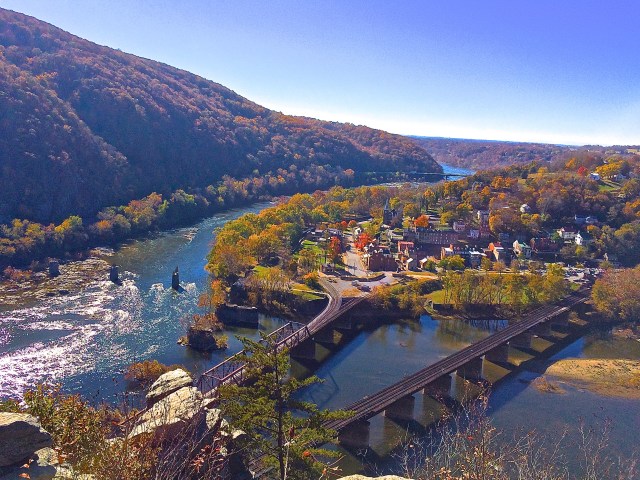
It was the first week in November and I was determined to keep a promise I made to myself. Earlier, during the last week of September I made the trek to the Maryland Heights Overlook and took photos that included the view from above the confluence of the Shenandoah and Potomac rivers, the surrounding mountains and the town of Harpers Ferry. I knew then that I had to make the trek again when the leaves were turning. I was a week late, from a peak color point of view, but I had to give it a try.

The geographical location of Harpers Ferry, combined with the abundance of natural resources shaped it’s history. The confluence of the Shenandoah and Potomac and the forming of the gap in the Blue Ridge Mountains provided a way to travel from east to west and also created a space of spectacular beauty. Upon his arrival to this area in 1747, Robert Harper was inspired to write: “O Thou great Being above, whose hands but Thine could have created so much sublimity and grandeur.”
Not a cloud in the sky – no wind and about 60 degrees – a great way to start a hike. The trail map says its about 2.75 miles from Harpers Ferry, across the Potomac, follow the old tow path along the Potomac River then up the mountain to the Maryland Heights Overlook.

The way is flat and easy strolling till you get to the mountain trail. The trail (blazed by Union troops during the Civil War who made it wide enough to get cannon up the mountain in a effort to hold the river) will easily accommodate hiking two abreast up the mountain. However, it is a little steep. I’m a slow, stop and “admire the view,” hiker and I noticed that as the trail continued my view admiring became more frequent.

As I began the hike by walking the bridge that spans the Potomac I was struck with the feeling that there was something magical about the confluence of the Shenandoah and the Potomac. Maybe it just seems that way because you can get such an up-close view of two clear water rivers coming together in such a joyful way. It is as if they were two young girls running together, joining hands and racing through the gap in the mountains. There is no shortage of places and perspectives to observe this mesmerizing event. One of my favorites is from the bridge.
Once across the bridge you head north on a well-maintained old towpath that occupies the space between the Potomac River and what was the old Chesapeake and Ohio Canal. This towpath hugs the Potomac and C & O Canal for 184 miles (from Washington DC to Cumberland Maryland.) As you walk north giant Sycamores, growing in single file along the bank of the Potomac, provide shade. Kayakers and rafters negotiate the rocks and rapids as the river pushes by you toward Washington.

The Blue Ridge Mountains form a beautiful natural barrier off to the right, just beyond the dry canal bottom that was the C&O Canal and a narrow winding road that twists and turns like the contour lines on a map. One hundred and eighty-four miles of level maintained trail, with the rambunctious Potomac on one side and the Blue Ridge Mountains on the other, makes for great hiking/biking.
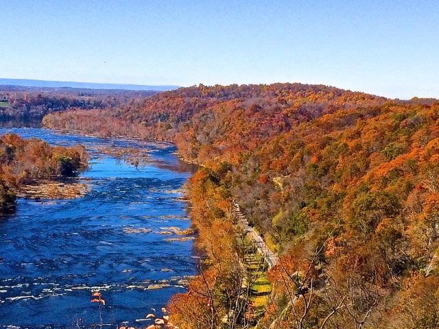
A few hundred yards down the towpath you turn right, cross the old canal on a narrow hiking bridge, then across the road where the mountain portion of the hike begins. The trail leads up the mountain through a hardwood forest and stays fairly steep except for a few short flat sections that keep your spirits up.

It took me 1 hour and 45 min to hike to the overlook starting from the parking lot at the train station in Harpers Ferry and 1 hour and 5 min to hike back down. During the 2 and a half months that I have been exploring the area, I have been to Harpers Ferry 4 times and twice hiked up the mountain. I love it. If you are ever in the neighborhood, come take a look.

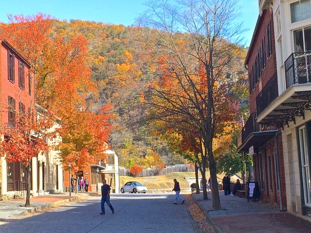
Beautiful ‘fall colors’ in Harpers Ferry !
LikeLike